Aerial Surveillance Systems / Technical Datasheet
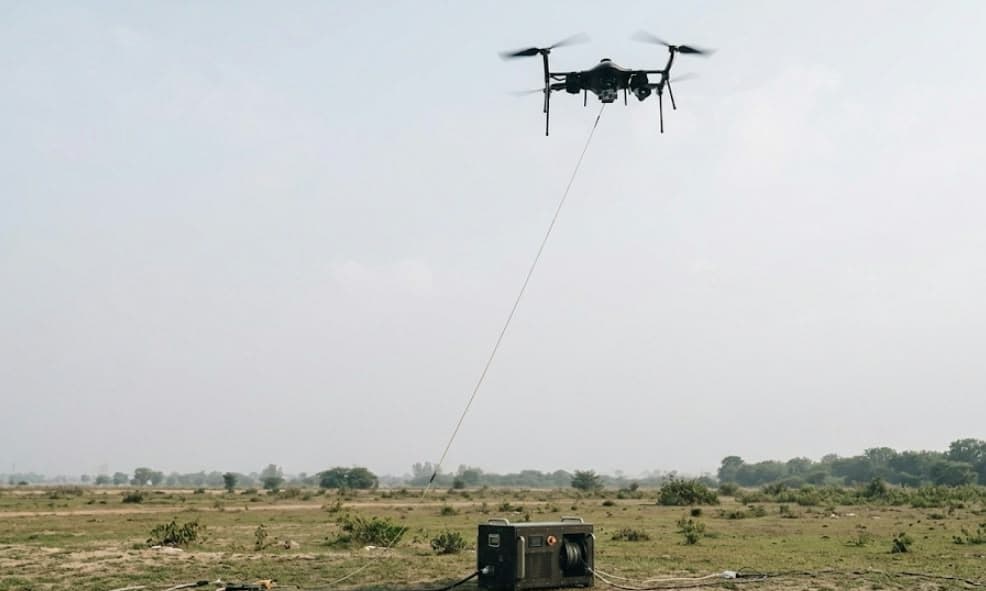
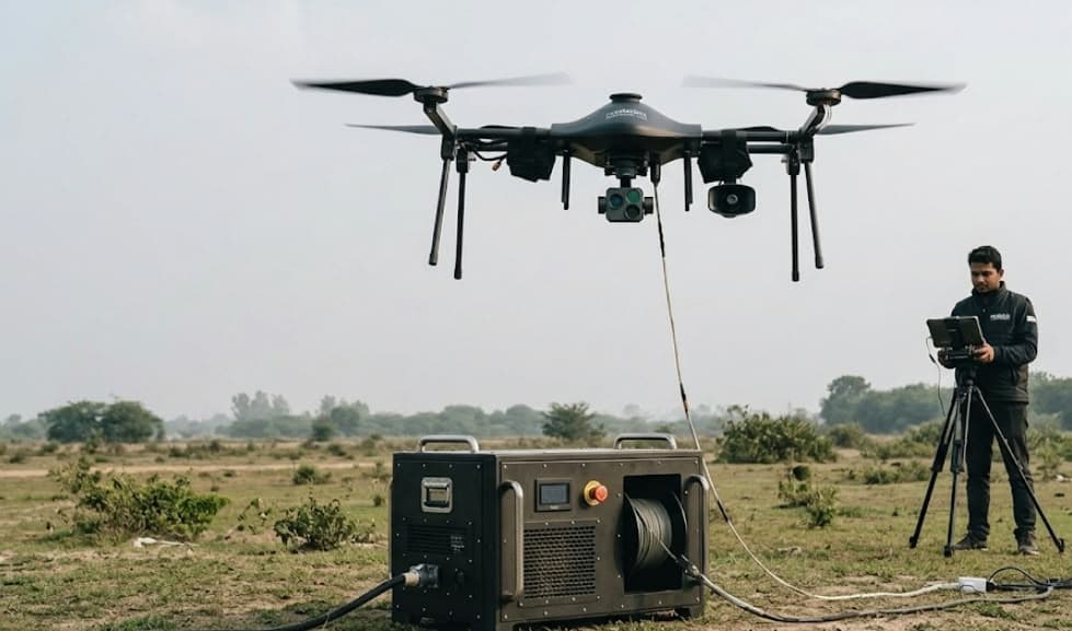
Tethered Surveillance UAV
Persistent day and night surveillance with untethered flight capability.
What it enables
Persistent aerial awareness, on demand.
Extended tethered overwatch pairs with a rapid free-flight option, EO/IR sensing and coordinated ground control.
Rodella Technologies Pvt. Ltd.
Aerial surveillance systems
System at a glance
- Tethered endurance
- 12+ hours
- Untethered endurance
- 35+ min
- Tethered operating altitude
- 120+ m AGL
- Tether station output
- 3,000 W
- Tether cable length
- 150 m
- Power base station
- ≤40 kg
System details / 01
Air vehicle & flight envelope
- Platform
- Electrically propelled quad-rotor air vehicle with autonomous VTOL, stabilized stationkeeping and fixed-height hover. Live GCS command authority extends through payload-safe recovery.
- Range / launch
- Free-flight mission range: 2 km. Launch-site elevation capability: ≥1,000 m AMSL. Free-flight height limit subject to configuration confirmation.
- Mid-flight release
- GCS-commanded airborne tether separation at ≥50 m, followed by a minimum 35-minute free-flight mission.
- Wind
- Launch, recovery and mission operation in winds ≥20 km/h. Airframe wind tolerance: 35 km/h sustained and 50 km/h gusts.
- Weight / setup
- Flight-ready aircraft mass ≤70 kg with battery and one mission payload. Rigging and derigging each <15 minutes, with two-person transport and deployment.
- Environment
- Operating and storage envelope: -10°C to +55°C. Damp-heat endurance at 40°C / ≥95% RH, with tolerance to dust, drizzle and humid field conditions.
System details / 02
Mission system & EO/IR payload
- Public address
- Airborne public-address payload available in tether-supported and free-flight mission modes.
- Stabilization
- Gimbal-stabilized electro-optical / infrared sensor suite with digital image stabilization across the zoom range to suppress airframe vibration effects.
- Day camera
- Visible-spectrum colour imager: 1920 × 1080 pixels, 360° non-continuous azimuth travel, 90° elevation travel, 30× optical magnification and 4× digital zoom.
- Field of view
- Narrow-field coverage ≤5°. Wide-field value: 245° (subject to camera configuration confirmation).
- Day detection
- Daylight human-sized target detection envelope: 1,500 m.
- Night camera
- Infrared imager: 640 × 480 pixels, selectable white-hot / black-hot polarity and ≥4× digital zoom. Human-sized target detection envelope: 700 m.
System details / 03
Flight safety & power redundancy
- Failsafes
- Loss-of-link recovery initiates automatic return-to-home. Low-energy or supply-loss events trigger return-to-home / controlled landing.
- Backup power
- Uninterrupted transfer to onboard reserve energy provides ≥30 minutes of airborne operation after ground-power loss. Ground reserve supports tether retrieval.
- Navigation
- Dual or higher onboard GPS architecture provides navigation redundancy.
System details / 04
Ground control segment
- Hardware
- Rugged GCS specified to MIL-STD-810G, with Intel Core i5 vPro processing ≥2.1 GHz, system memory ≥16 GB and onboard storage ≥500 GB.
- Display / power
- Sunlight-viewable anti-glare XGA display ≥10 inches, 1024 × 768 pixels. Peak-load battery autonomy ≥2 hours, with recharge <3.5 hours.
- Ports
- Operator interfaces include VGA, HDMI, USB and 10/100/1000 Ethernet, with external-storage connectivity for mission-data export.
- Flight interface
- Flight-command console with aircraft / propulsion telemetry. Persistent moving-map and live-video views show position, AGL height, mission elapsed time and artificial-horizon / altitude indication.
- Payload / joystick
- Operator / joystick authority for day-night sensor selection, pan-tilt-zoom, thermal polarity, RPV mode and commanded flight altitude.
- Diagnostics
- Pre-launch built-in self-test with live input/output voltage and deployed tether-length indication.
System details / 05
Command, control & data links
- Tethered
- Fibre-optic digital command and return-data paths carry aircraft control, platform / payload telemetry and EO/IR video without RF transport in tethered mode.
- Untethered
- Free-flight uplink/downlink specified in S and C bands, with preference for licence-free 2.4 GHz or 5.8 GHz operation.
System details / 06
Ground power & tether assembly
- Input / output
- Ground power interface: 220 V AC ±10%. Nominal power delivery: 3,000 W. Tether base-unit mass: ≤40 kg.
- Winch
- Aircraft-calibrated motorized reel manages payout and retrieval automatically during climb/descent, using tension-based release control without manual cable intervention.
- Protection
- Ventilated thermal management, electrically insulating enclosure / tether jacket, safety isolation switch and externally accessible emergency stop.
- Monitoring
- Ground-unit LCD reports supply voltage, delivered voltage and tether length. Integrated reserve battery maintains reel payout / retrieval following mains interruption.
- Network / cable
- Secure optical-network interface supports existing infrastructure. Base unit houses ≥150 m tether with tensile capacity ≥50 kg, enabling low-manpower field operation.
System details / 07
Untethered heavy-lift UAV
A mobile aerial platform with mission planning and remote support, available as part of the integrated surveillance system.
- Airframe & performance
- Battery-electric heavy-lift multirotor in Quadra / Hexa-X geometry, 31.5 kg maximum takeoff mass, compass-independent operation and obstacle sensing. Mission height: 120 m AGL; cruise / maximum speed: 5.5 / 10 m/s; vertical climb / descent rate: 2 / 1.25 m/s.
- Mission capability
- 10 kg payload, 10 km maximum range and up to 20 minutes operational flight time. Operational wind tolerance: 20 km/h; ambient operating envelope: -10°C to +50°C.
- Landing
- Autonomous touchdown accuracy: 0.5–0.8 m. Launch / recovery area values: 1.5 × 1.5 m and 5 × 5 m, with allocation subject to site-layout confirmation.
- Control & communications
- Windows mission-planning station with route generation, pre-mission data preparation, aircraft position / height / energy status and advanced operator warnings. 2.4 GHz command transmitter with 4G/5G telemetry connectivity and access-controlled remote GCS support.
- Onboard energy
- Lithium-ion battery, 27,000 mAh / 50.4 V, 5.2 kg with 45-minute charging time. Bluetooth-enabled battery charge-cycle tracking.
- Autonomy & navigation
- Electronic / vision-assisted terminal guidance recognizes landing markers for recovery within a 5 × 5 m landing zone. Node-level launch sequencing works through a mobile application or local push-button without 4G/5G dependence. Redundant dual-GPS installation with simultaneous multi-constellation reception.
- Component design life
- Battery: 300 cycles. Airframe: 15,000 flight hours. Propulsion: 5,000 flight hours. Propellers: 2,500 flight hours.
- Quality
- Quality-management certification specified to ISO 9001:2015, with supporting certification for the offered solution.
System details / 08
ICCC mission system interface
Unified ICCC visibility, coordinated operations and project delivery.
- Live video / analytics
- Stream each air vehicle’s imagery and telemetry to the central VMS / AI processing environment for crowd-density estimation, movement-flow analysis and anomaly detection.
- Fleet visibility
- Publish fleet geolocation, height and mission status as a common aerial layer within ICCC GIS / Digital Twin views, alongside fixed surveillance and field assets.
- Alerts / intervention
- Feed airborne detections into ICCC incident workflows. Expose the PA payload as a remotely addressable channel for crowd-management intervention.
- Dispatch / recognition
- Enable ICCC tasking of free-flight aircraft through Computer-Aided Dispatch (CAD) resource registration. Whitelist both platform types within Counter-UAS friend-or-foe identification.
- Data management
- Synchronize aerial video / telemetry to the common time reference and Layer-3 data lake, applying the video-retention framework used for fixed-camera assets.